![]()
An integrated solution for getting contrail sightings from your mobile to the scientists’ desktop.
CLASA supplied an online web dashboard where you can report contrail sightings. Doing so allows NASA to build a database on contrails, answering questions like: - where contrails are forming? - how long are they hanging around for? - what effect might they be having on the environment?
Sorry, the app is no longer live. But keep on scrolling for screenshots.
Background
Clouds or Contrails
This product was developed as a part of the NASA Space Apps challenge, solving the proposed Clouds or Contrails challenge. This challenge sees competitors design an app for identifying and tracking contrails.
![]()
What are contrails?
Contrails are the streaks of clouds left behind planes as they fly through the sky. They are formed due to the plane’s exhaust causing moisture in the air to condense. It is estimated that in some parts of the world, contrails may account for up to 2% [1] of the cloud cover: a small yet potentially significant amount.
The big problem is: we don’t know!
More data on contrails is required to be able to answer many of the looming questions. CLASA proposes a solution in which you hold the key to help collect this data.
Solution
The solution
The proposed solution consists of two phases of data collection. In Phase I, data collection relies on crowdsourcing, and for participation from the public. In Phase II, data collection becomes automated and the rate at which data may be collected is accelerated. The project is currently in Phase Ⅰ.
Phase I
The Dashboard: The web dashboard is designed to provide a simple platform for users to report contrail sightings, and to upload pictures of the contrails. This platform is targeted at users who wish to participate and inform NASA altruistically. It is designed to be fast and easy to use. A web app is used so that users don’t need to download the product ahead of time.
Machine Vision: Users are required to upload a picture of the sighted contrail with their report. The reason for this is twofold:
- Firstly to provide data integrity. A classifier is able to determine the likelihood that images contain contrails, flagging suspected “problem” users.
- To provide a large learning dataset for extending to Phase II.
Phase IA
Note that this part of Phase I is not yet implemented.
The Game: Should the standard web dashboard not attract enough end users, alternative markets may be used to acquire users. Integration with existing games further allows an existing user-base to be tapped into. CLASA’s contrail-spotting platform could be implemented into existing virtual reality games. For example Ingress, which has as many as 7 million players, could be extended to allow “capture” of contrails.
Phase II
After Phase I, a considerable dataset of contrail images is expected to have been collected. Using this dataset and lessons learnt improving the existing machine vision implementation, a completely automated solution will be released. This platform is able to recognise contrails in publicly available webcam feeds, and geo-tagged photo and video uploads to social media.
Dashboard
The Reporting Dashboard
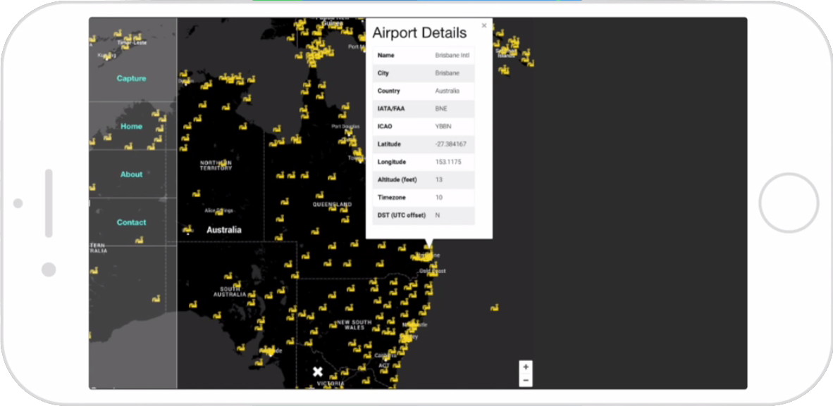
The web app presents users with a map showing their current location, and nearby airports and flight paths. This information is presented to allow the user to infer what flight a contrail may have come from. The page is responsive, meaning that it adjusts to screen size: it works equally well on a mobile device or a computer screen.
If the user would like to report a contrail sighting, they hit the Capture button. They are then asked to take a photo, or upload an existing one, and given the option to add a comment to the sighting. In future, the app will also show other recent contrail sightings in your area. Apart from some other administrative options (such as About and Contact), the interface is kept simple and minimum.
Vision
Machine Vision
Machine vision is used to automatically identify the likelihood an image contains a contrail. The algorithm developed is explained in further detail in the Readme on its GitHub page.
In brief, first image pre-processing ensures that all images arriving to the algorithm are consistent, regardless of the camera used or the lighting in the image.

Next a set of features are extracted. These are mathematical properties of the image that we think might help the computer know if contrails are present or not. A classifier is trained using a series of input data. For the challenge, this data was obtained using Google Images, searching for “contrails” and “cirrus”. The classifier used was a Random Forest classifier.
The classifier was able to achieve about 75% accuracy. We believe this could be greatly improved with some development and a better dataset.
Links
Project Links
Resources
- FlightStats flight information API.
- SinglePaged theme, by Tim O’Brien.
- Font Awesome icons, by Dave Gandy.
- Pillow, NumPy and SciPy Python modules for machine vision.